Angola has a tropical to subtropical climate, with warm temperatures throughout the year and distinct rainy and dry seasons. However, its large size and varied geography mean that climate conditions differ considerably across the country.
Angola’s climate at a glance
Warmest average month
October
23.3°C
Coolest average month

July
18.6°C
Wettest month nationally
March
181.4 mm
Driest months nationally

June &
July
Main rainy period

October–April
Main dry
period

May–September
Temperature and precipitation figures are from CRU-CY v4.10, Climatic Research Unit, University of East Anglia. National averages for 1991–2020.
What is the climate of Angola?
Angola lies in tropical southwestern Africa, but describing its climate simply as “tropical” hides some substantial differences across the country.
Rainfall generally decreases from north to south. Northern Angola has a much longer rainy season, while the south is considerably drier. At the same latitude, inland areas generally receive more rain than the Atlantic coast, and precipitation also tends to increase with elevation.
Elevation has an equally noticeable effect on temperature. Lower-lying areas can remain hot throughout the year, whereas Angola’s central plateau has a considerably milder climate.
The difference can be striking: Soyo, near the mouth of the Congo River, has historically recorded an average annual temperature of about 26°C, compared with under 16°C at high-altitude Huambo. Frost can even occur at higher elevations during the coolest part of the year.
Climate types in Angola
This map shows the main climate types found across Angola. Each color represents a different climate type, based mainly on long-term patterns of temperature and rainfall.
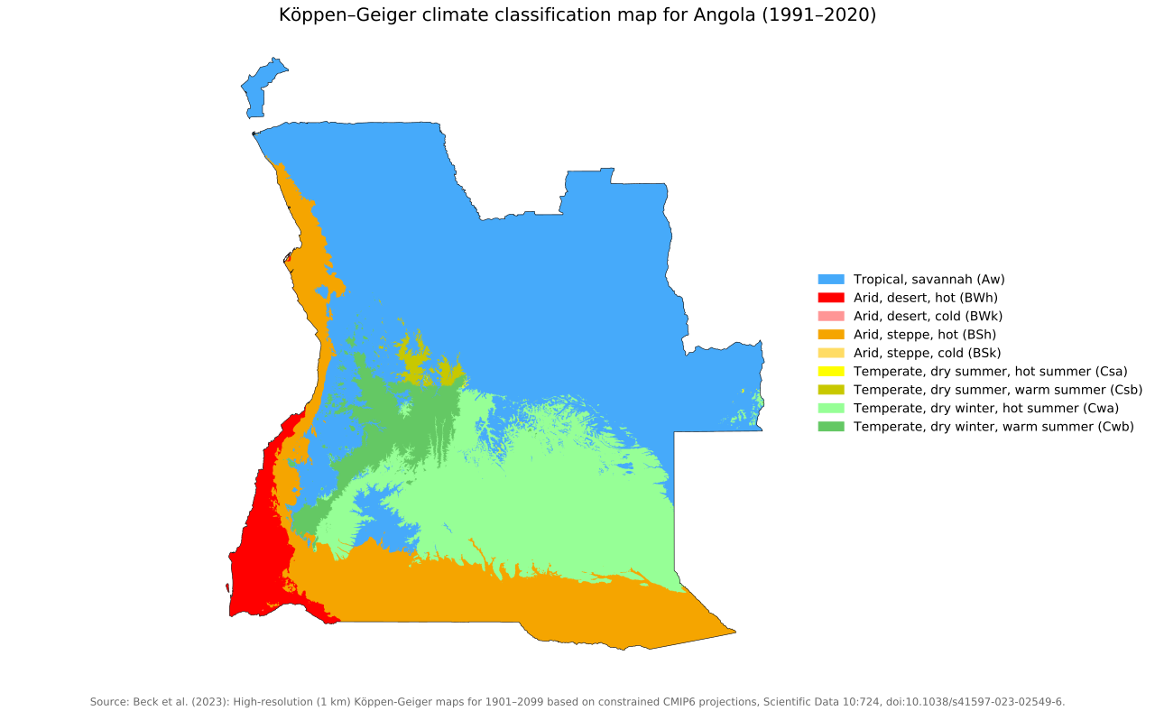
Angola contains tropical, arid and temperate climate types, reflecting its considerable differences in rainfall, elevation and location.
Tropical climates cover much of northern Angola, while increasingly dry conditions occur toward the southwest. The far southwestern coastal area contains some of the country’s most arid climates, partly due to the cold Benguela Current. Cooler temperate climate types occur across parts of the elevated interior.
The climate map therefore shows something that national averages cannot: two places in Angola can experience substantially different temperature and rainfall conditions even though they are in the same country.
Temperatures in Angola
Angola is warm throughout the year, but there is a clear seasonal temperature cycle.
Data for 1991–2020 show average temperatures range from about 18.6°C in July to 23.3°C in October. Average daytime maximum temperatures vary less dramatically, remaining at roughly 27–30°C throughout the year.
The difference is particularly noticeable at night. Average daily minimum temperatures are around 17°C from November through March but fall to approximately 10°C in July.
| Month | Avg. minimum | Avg. temperature | Avg. maximum |
|---|---|---|---|
| January | 17.3°C | 22.8°C | 28.4°C |
| February | 17.5°C | 22.9°C | 28.5°C |
| March | 17.5°C | 23.0°C | 28.7°C |
| April | 16.4°C | 22.6°C | 28.9°C |
| May | 13.8°C | 21.2°C | 28.8°C |
| June | 10.8°C | 19.0°C | 27.2°C |
| July | 10.3°C | 18.6°C | 26.9°C |
| August | 12.2°C | 20.4°C | 28.6°C |
| September | 14.7°C | 22.3°C | 30.0°C |
| October | 16.7°C | 23.3°C | 30.0°C |
| November | 17.1°C | 23.0°C | 28.9°C |
| December | 17.3°C | 22.8°C | 28.4°C |
These are countrywide averages, so they should not be interpreted as the temperature of every part of Angola. Higher areas of the central plateau are considerably cooler than many other parts of the country.
Rainfall in Angola
Rainfall in Angola is highly seasonal.
Data for 1991–2020 show national precipitation increasing rapidly toward the end of the year and remaining high through the first months of the following year. March is the wettest month in the national dataset, averaging about 181.4 mm of precipitation.
| Month | Precipitation |
|---|---|
| January | 161.0 mm |
| February | 148.6 mm |
| March | 181.4 mm |
| April | 112.7 mm |
| May | 16.5 mm |
| June | 0.8 mm |
| July | 0.8 mm |
| August | 4.2 mm |
| September | 22.5 mm |
| October | 76.4 mm |
| November | 148.8 mm |
| December | 165.9 mm |
Rainfall then drops dramatically. Average precipitation is only 16.5 mm in May, followed by less than 1 mm in both June and July. Rain begins increasing again from August and September before the wetter conditions return in October.
Again, these national figures hide major geographical differences. Northern Angola is generally wetter than southern Angola, while inland areas tend to receive more precipitation than coastal locations at the same latitude.
Rainy and dry seasons in Angola
Angola’s year can broadly be divided into a rainy season and a dry season, although their timing differs across the country.
In northern Angola, the rainy season can last for around seven months, generally from September to April, sometimes with a reduction in rainfall during January or February. In southern Angola, it begins later, usually around November, and may end around February.
Across the country more broadly, the main rainy period occurs around October to April as the Inter-Tropical Convergence Zone (ITCZ) moves over Angola.
The dry season is locally known as the cacimbo. It generally occurs during the cooler part of the year and can be characterised by heavy morning mist. June and July sit near the heart of this dry period and receive almost no rainfall.
How is Angola’s climate changing?
Angola has already experienced substantial warming. Mean annual temperature increased by approximately 0.2°C per decade from 1951, amounting to about 1.4°C of warming.
Changes in rainfall are less straightforward. Trends vary across Angola, and there is considerable uncertainty about future precipitation. Southern Angola has nevertheless experienced severe droughts in recent decades.
Temperatures are expected to continue rising. Climate projections also indicate that Angola could experience longer dry periods alongside more intense heavy-rainfall events, although the scale and direction of rainfall changes vary geographically.
References
Harris I, Osborn TJ, Jones P and Lister D (2020) Version 4 of the CRU TS Monthly High-Resolution Gridded Multivariate Climate Dataset. Sci Data 7, 109. https://doi.org/10.1038/s41597-020-0453-3
Correia, C. D. N., Fonseca, A., Amraoui, M., Pereira, C. A., & Santos, J. A. (2025). Long-term climate trends in southern Angola and possible implications in agriculture. Climate, 13(9), 173. https://doi.org/10.3390/cli13090173

Caitriona Maria is an education writer and owner of The Facts Institute. With seven years of teaching experience and a background in educational content, she specialises in creating clear reference resources about countries, geography and global topics.