Algeria, in Northern Africa, has a highly varied climate, ranging from Mediterranean conditions in the far north to extremely dry desert conditions across most of the country. Much of southern Algeria lies within the Sahara and is almost entirely desert.
Algeria’s climate at a glance
Warmest average month
July
33.4°C (92.1°F)
Coolest average month
January
12.3°C (54.1°F)
Wettest month nationally
January
10.8 mm (0.43 in)
Driest month nationally

July
2.4 mm (0.09 in)
Temperature and precipitation figures are from CRU-CY v4.10, Climatic Research Unit, University of East Anglia. National averages for 1991–2020.
What is the climate of Algeria?
Most of Algeria is dominated by the Sahara Desert, which covers more than 80% of the country’s land area. Conditions across this vast interior are extremely dry, while the northern part of Algeria has a much milder and wetter climate.
Along the Mediterranean coast and the Tell Atlas, winters are relatively mild and receive much of the year’s rainfall. Rainfall generally decreases farther inland, while the High Plateaus form a drier transition between the Mediterranean north and the Sahara.
Along the Mediterranean side of the Tell Atlas, annual rainfall commonly reaches several hundred millimetres, with the wetter conditions generally found farther east. Parts of northeastern Algeria can receive close to 1,000 mm (39 in) in particularly wet years. Farther south, rainfall becomes increasingly scarce.
Temperature also varies substantially. Northern coastal areas are moderated by the Mediterranean, while the desert interior experiences much hotter summer days. Desert temperatures can also fall rapidly after sunset because the air is so dry that heat escapes rapidly, producing large differences between daytime and nighttime temperatures.
Climate types in Algeria
This map shows the main climate types found across Algeria. Each color represents a different climate type, based mainly on long-term patterns of temperature and rainfall.
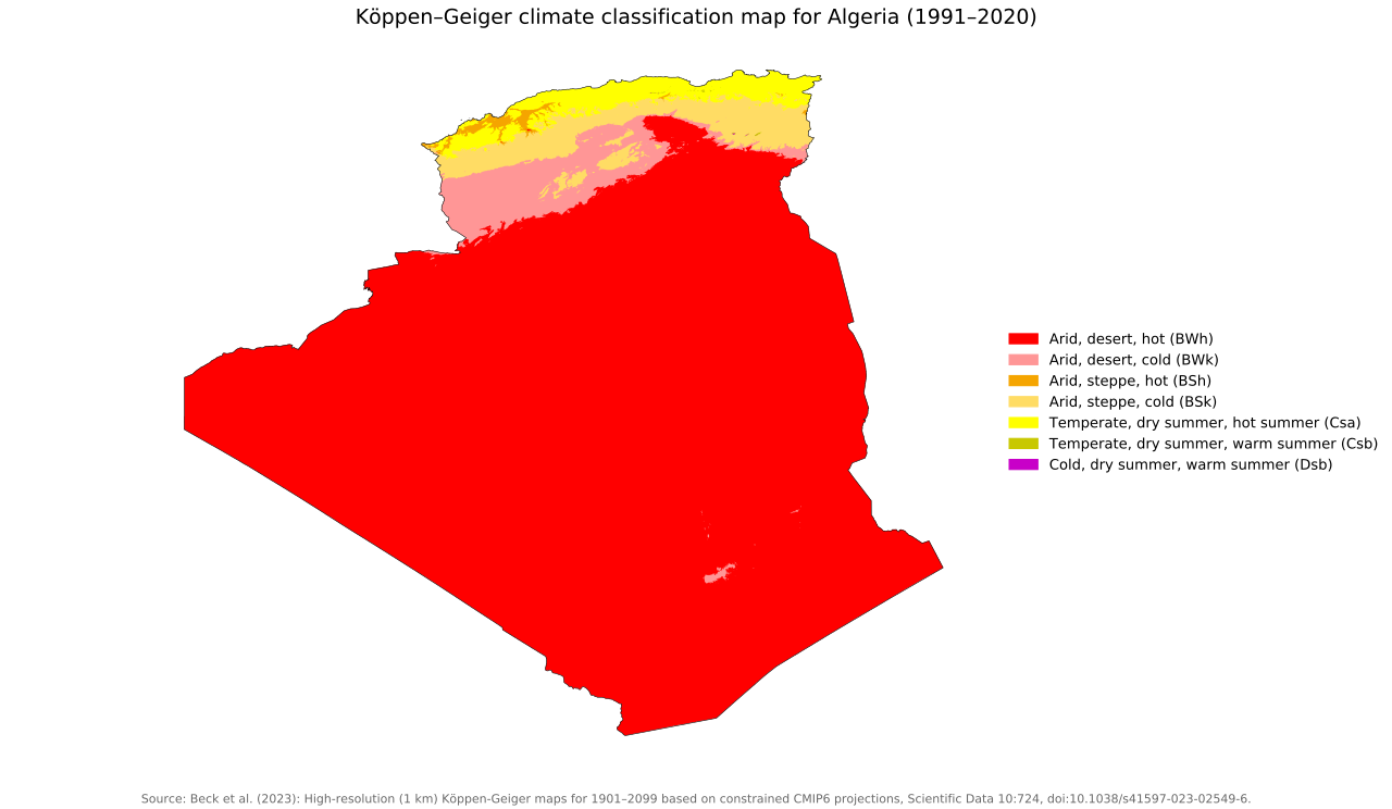
Most of Algeria is dominated by a hot desert climate, which covers almost all of the central and southern parts of the country. A cold desert climate appears mainly farther north, forming a broad transition zone between the Sahara and the northern part of Algeria.
Across northern Algeria, the climate becomes more varied. Hot and cold steppe climates occur in belts across the north, while Mediterranean climates with dry summers are concentrated along the far north, including around Algiers, and in some northern upland areas.
Overall, the map shows a clear shift from overwhelmingly desert conditions in the south and interior to steppe and Mediterranean climates toward the north.
Temperatures in Algeria
Algeria experiences a strong seasonal temperature cycle, with the highest temperatures occurring during the northern summer.
Data for 1991–2020 show that the national average temperature rises from about 12.3°C (54.1°F) in January to 33.4°C (92.1°F) in July. Average daytime maximum temperatures increase even more sharply, from about 19.2°C (66.6°F) in January to 41.0°C (105.8°F) in July.
Average minimum temperatures range from approximately 5.4°C (41.7°F) in January to 25.8°C (78.4°F) in July. The difference between average daytime maximum and nighttime minimum temperatures is substantial throughout the year, particularly across the dry interior.
| Month | Avg. minimum | Avg. temperature | Avg. maximum |
|---|---|---|---|
| January | 5.4°C (41.7°F) | 12.3°C (54.1°F) | 19.2°C (66.6°F) |
| February | 7.8°C (46.0°F) | 14.9°C (58.8°F) | 22.1°C (71.8°F) |
| March | 11.5°C (52.7°F) | 18.7°C (65.7°F) | 26.0°C (78.8°F) |
| April | 15.4°C (59.7°F) | 22.9°C (73.2°F) | 30.3°C (86.5°F) |
| May | 19.9°C (67.8°F) | 27.3°C (81.1°F) | 34.8°C (94.6°F) |
| June | 24.2°C (75.6°F) | 31.8°C (89.2°F) | 39.3°C (102.7°F) |
| July | 25.8°C (78.4°F) | 33.4°C (92.1°F) | 41.0°C (105.8°F) |
| August | 25.6°C (78.1°F) | 32.9°C (91.2°F) | 40.3°C (104.5°F) |
| September | 22.6°C (72.7°F) | 29.6°C (85.3°F) | 36.8°C (98.2°F) |
| October | 17.6°C (63.7°F) | 24.5°C (76.1°F) | 31.4°C (88.5°F) |
| November | 11.4°C (52.5°F) | 18.1°C (64.6°F) | 25.0°C (77.0°F) |
| December | 6.8°C (44.2°F) | 13.5°C (56.3°F) | 20.2°C (68.4°F) |
These are countrywide averages and should not be interpreted as typical temperatures everywhere in Algeria. The Mediterranean coast is considerably milder than much of the Sahara. At Algiers airport, for example, historical climate averages show a mean temperature of about 11.1°C (52.0°F) in January and 26.0°C (78.8°F) in August, with average daytime highs of around 16.7°C (62.1°F) and 32.2°C (90.0°F) respectively.
Rainfall in Algeria
Algeria is an exceptionally dry country overall, although rainfall varies enormously from north to south.
The 1991–2020 national figures show relatively little precipitation in every month because the vast Sahara accounts for most of Algeria’s land area. January is the wettest month in the national dataset, with an average of about 10.8 mm (0.43 in), while July is the driest at only 2.4 mm (0.09 in).
Rainfall generally increases during autumn and winter and decreases toward summer. National precipitation falls below 7 mm (0.28 in) per month from May through August before increasing again in September and October.
The countrywide averages, however, hide the much wetter conditions of northern Algeria. Coastal parts of the Tell commonly receive several hundred millimetres of rainfall each year, compared with extremely small amounts across much of the Sahara.
| Month | Precipitation |
|---|---|
| January | 10.8 mm (0.43 in) |
| February | 8.3 mm (0.33 in) |
| March | 9.0 mm (0.35 in) |
| April | 7.9 mm (0.31 in) |
| May | 6.5 mm (0.26 in) |
| June | 2.9 mm (0.11 in) |
| July | 2.4 mm (0.09 in) |
| August | 6.3 mm (0.25 in) |
| September | 8.6 mm (0.34 in) |
| October | 9.3 mm (0.37 in) |
| November | 9.8 mm (0.39 in) |
| December | 9.8 mm (0.39 in) |
How is Algeria’s climate changing?
Algeria has experienced substantial warming in recent decades. According to the International Energy Agency, the country’s mean surface temperature increased by about 0.49°C (0.88°F) per decade between 2000 and 2023, compared with about 0.37°C (0.67°F) per decade globally over the same period. Heatwaves have also become more frequent, longer and more intense.
Temperatures are expected to continue rising. By the end of the century Algeria’s mean temperature could be around 2.6°C (4.7°F) above pre-industrial levels under a low-emissions scenario and as much as 5.6°C (10.1°F) higher under a high-emissions scenario.
Climate change is also expected to alter rainfall patterns across Algeria. Northern areas are projected to become drier, increasing the risks of drought and wildfires, while parts of the Sahara could experience more extreme rainfall events and flash flooding.
References
Harris I, Osborn TJ, Jones P and Lister D (2020) Version 4 of the CRU TS Monthly High-Resolution Gridded Multivariate Climate Dataset. Sci Data 7, 109. https://doi.org/10.1038/s41597-020-0453-3.

Caitriona Maria is an education writer and owner of The Facts Institute. With seven years of teaching experience and a background in educational content, she specialises in creating clear reference resources about countries, geography and global topics.