Cameroon has a tropical climate overall, but conditions vary considerably across the country. Located just north of the Equator in Middle Africa, it stretches from the humid Gulf of Guinea coast toward the much drier Sahel.
Cameroon’s climate at a glance
Warmest average month
March & April
26.8°C (80.2 °F)
Coolest average month
August
23.6°C (74.5 °F)
Wettest month nationally
September
266.6 mm (10.50 in)
Driest month nationally

January
13.4 mm (0.53 in)
Temperature and precipitation figures are from CRU-CY v4.10, Climatic Research Unit, University of East Anglia. National averages for 1991–2020.
What is the climate of Cameroon?
Cameroon stretches across several very different climate regions, from the humid equatorial south to the much drier far north.
Rainfall generally decreases toward northern Cameroon, while some of the heaviest rainfall occurs along the southwestern coast and nearby highlands. Moist oceanic air is forced upward by the steep slopes of Mount Cameroon, helping to produce exceptionally heavy rainfall in parts of the southwest.
Debundscha Point on Mount Cameroon (along with the nearby village of Debundscha) has historically received more than 10,000 mm (394 in) of rainfall per year.
Farther inland and northward, the climate becomes increasingly seasonal. On the Adamawa Plateau, annual rainfall is still substantial, at around 1,500 mm (59 in) in the Ngaoundéré area, while its higher elevation keeps temperatures milder than in many lower-lying parts of Cameroon.
Northern Cameroon has a much longer dry season. In the extreme north, rainfall is concentrated into only a few months of the year.
Climate types in Cameroon
This map shows the main climate types found across Cameroon. Each color represents a different climate type, based mainly on long-term patterns of temperature and rainfall.
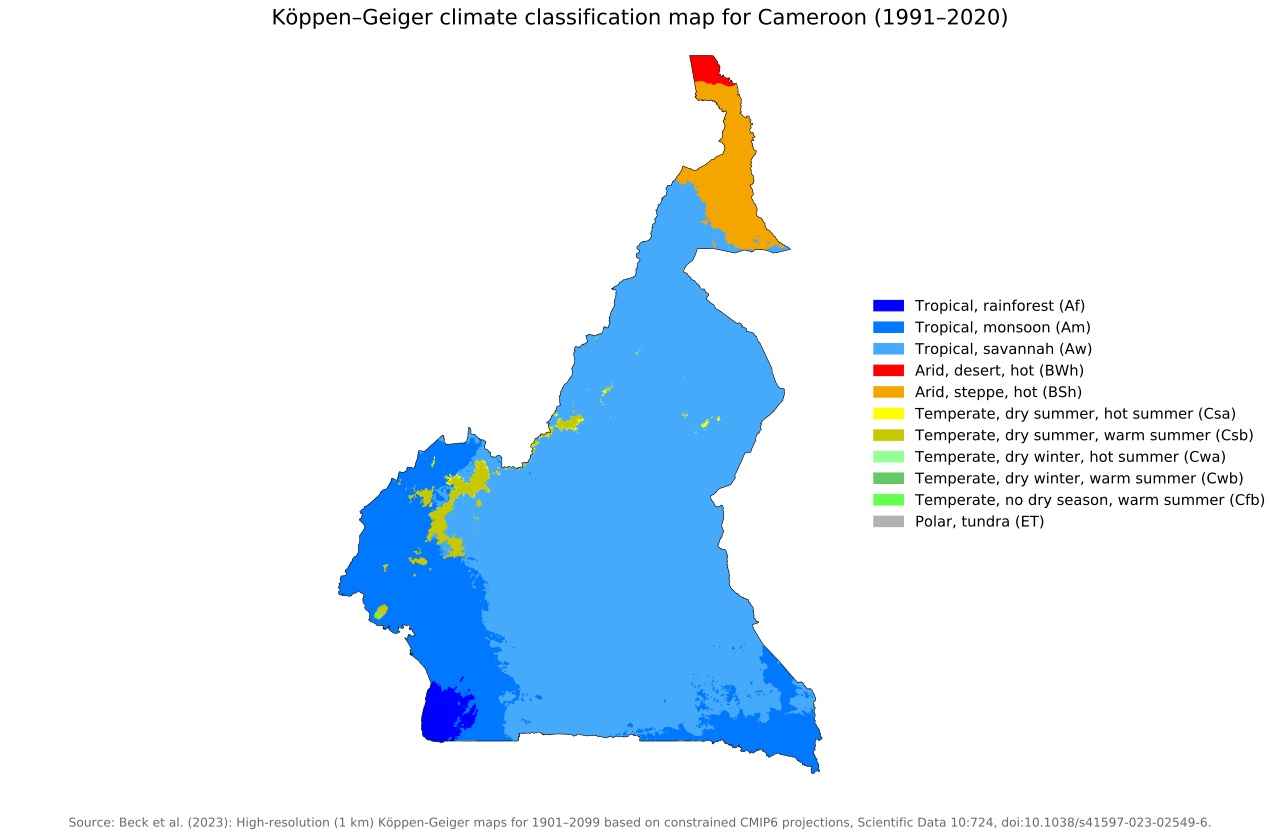
Most of Cameroon has a tropical savanna climate, which covers a large part of the center, east and north of the country. This includes areas around Yaoundé and farther north toward Garoua.
The map also shows much more local climate variation along Cameroon’s borders and coastal areas than across much of the interior. In the south and southwest, this gives way to tropical monsoon climate, including around Douala, while a smaller area near the southwestern coast has a tropical rainforest climate.
The far north is much drier, with a hot semi-arid climate covering much of the northernmost region, including around Maroua, and a small area of hot desert climate at the extreme northern tip.
Temperatures in Cameroon
Cameroon remains warm throughout the year, and national average temperatures vary much less between seasons than they do in countries farther from the equator.
Data for 1991–2020 show average temperatures ranging from about 23.6°C (74.5°F) in August to 26.8°C (80.2°F) in March and April. Average daytime maximum temperatures reach their highest level in March at around 32.9°C (91.2°F) before falling to approximately 27.5°C (81.5°F) in August.
Average minimum temperatures vary from about 17.6°C (63.7°F) in January to 21.3°C (70.3°F) in April.
| Month | Avg. minimum | Avg. temperature | Avg. maximum |
|---|---|---|---|
| January | 17.6 °C (63.7 °F) | 24.2 °C (75.6 °F) | 30.9 °C (87.6 °F) |
| February | 19.1 °C (66.4 °F) | 25.7 °C (78.3 °F) | 32.4 °C (90.3 °F) |
| March | 20.8 °C (69.4 °F) | 26.8 °C (80.2 °F) | 32.9 °C (91.2 °F) |
| April | 21.3 °C (70.3 °F) | 26.8 °C (80.2 °F) | 32.2 °C (90.0 °F) |
| May | 20.8 °C (69.4 °F) | 25.8 °C (78.4 °F) | 30.8 °C (87.4 °F) |
| June | 20.2 °C (68.4 °F) | 24.7 °C (76.5 °F) | 29.2 °C (84.6 °F) |
| July | 19.8 °C (67.6 °F) | 23.8 °C (74.8 °F) | 28.0 °C (82.4 °F) |
| August | 19.7 °C (67.5 °F) | 23.6 °C (74.5 °F) | 27.5 °C (81.5 °F) |
| September | 19.5 °C (67.1 °F) | 23.9 °C (75.0 °F) | 28.3 °C (82.9 °F) |
| October | 19.5 °C (67.1 °F) | 24.4 °C (75.9 °F) | 29.4 °C (84.9 °F) |
| November | 18.7 °C (65.7 °F) | 24.5 °C (76.1 °F) | 30.4 °C (86.7 °F) |
| December | 17.7 °C (63.9 °F) | 24.0 °C (75.2 °F) | 30.4 °C (86.7 °F) |
These are countrywide averages and hide important regional differences. Northern Cameroon is generally hotter, particularly during the dry season, while the western highlands and other elevated areas have considerably milder temperatures.
Rainfall in Cameroon
Cameroon receives substantial rainfall overall, but both the amount and seasonal pattern vary sharply across the country.
The 1991–2020 national figures show precipitation increasing rapidly from March and remaining high through much of the middle of the year. September is the wettest month in the national dataset, averaging 266.6 mm (10.50 in), while January is the driest at 13.4 mm (0.53 in).
| Month | Precipitation |
|---|---|
| January | 13.4 mm (0.53 in) |
| February | 25.7 mm (1.01 in) |
| March | 85.3 mm (3.36 in) |
| April | 129.1 mm (5.08 in) |
| May | 172.8 mm (6.80 in) |
| June | 181.6 mm (7.15 in) |
| July | 183.7 mm (7.23 in) |
| August | 244.3 mm (9.62 in) |
| September | 266.6 mm (10.50 in) |
| October | 224.3 mm (8.83 in) |
| November | 71.8 mm (2.83 in) |
| December | 17.1 mm (0.67 in) |
National rainfall remains above 100 mm per month from April through October, before falling sharply during November and December.
Rainy and dry seasons in Cameroon
The timing of the rainy season changes substantially across Cameroon.
In the south, there are generally two rainy periods, from March to June and again from August to November, with relatively drier conditions around December to February and July. The “dry” periods are generally times when rainfall decreases rather than stops altogether.
Farther north, there is one main rainy season, broadly from May to October, while in the extreme north it is concentrated mainly between June and September.
How is Cameroon’s climate changing?
Cameroon has experienced substantial warming in recent decades. Mean surface air temperature increased by approximately 0.29°C (0.52°F) per decade between 1971 and 2020, with the rate increasing to about 0.35°C (0.63°F) per decade between 1991 and 2020.
Temperatures are expected to continue rising. Under a high-emissions scenario, Cameroon’s average temperature for 2040–2059 is projected to be about 1.37°C (2.47°F) higher than during the 1995–2014 reference period.
Future projections suggest that Cameroon’s average rainfall could increase slightly. More noticeable changes may occur in rainfall patterns, with heavier extreme rainfall events, particularly in northern Cameroon, alongside shorter and more erratic wet periods.
Reference
Harris I, Osborn TJ, Jones P and Lister D (2020) Version 4 of the CRU TS Monthly High-Resolution Gridded Multivariate Climate Dataset. Sci Data 7, 109. https://doi.org/10.1038/s41597-020-0453-3.

Caitriona Maria is an education writer and owner of The Facts Institute. With seven years of teaching experience and a background in educational content, she specialises in creating clear reference resources about countries, geography and global topics.