The Caribbean is a region of North America consisting of thousands of islands, islets and cays, with 13 independent countries and numerous overseas territories.
Explore the interactive map above to discover the Caribbean’s countries and territories, capital cities and geographical features. Select a country or territory to view information about its population, area, capital and natural features, or use the map controls to explore different layers.
Where is the Caribbean on the world map?
The Caribbean is located southeast of the Gulf of Mexico, east of Central America and north of South America. It lies between the Atlantic Ocean and the surrounding coasts of North, Central and South America.
The region includes the Caribbean Sea and its many islands, along with island groups in the western Atlantic Ocean, such as The Bahamas and the Turks and Caicos Islands.
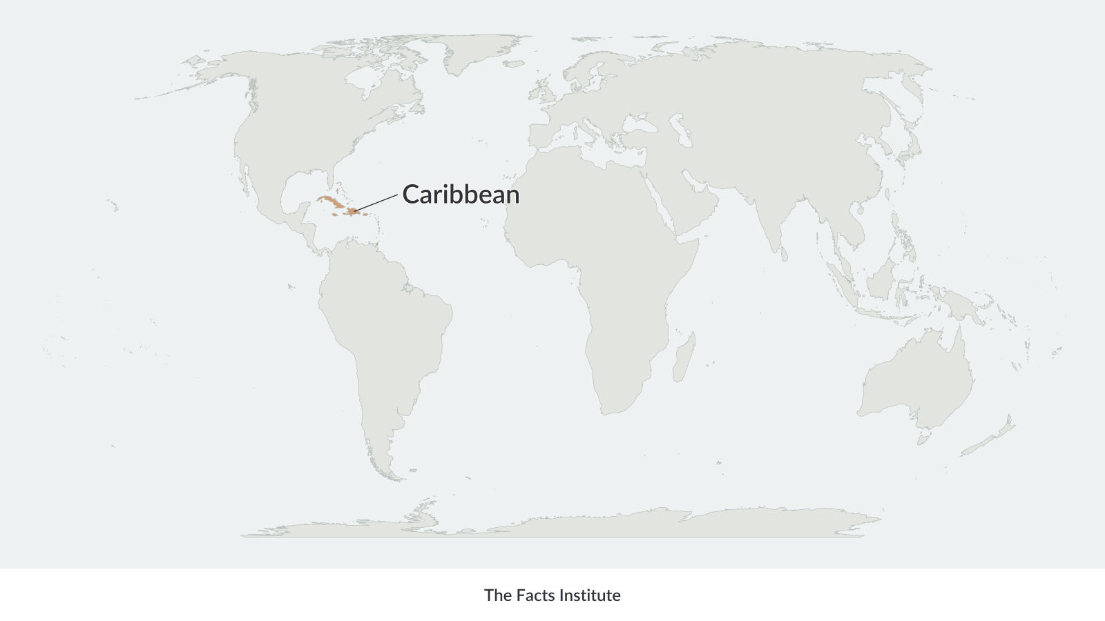
The Caribbean islands are commonly grouped into the Greater Antilles, Lesser Antilles and Lucayan Archipelago.
The Greater Antilles include Cuba, Hispaniola (shared by Haiti and the Dominican Republic), Jamaica and Puerto Rico. These are among the region’s largest islands.
The Lesser Antilles form an arc of smaller islands extending from the Virgin Islands southward toward Trinidad and Tobago. The Lucayan Archipelago, located north of Cuba, includes The Bahamas and the Turks and Caicos Islands.
Although geographically part of North America, the Caribbean is often treated as a distinct region because of its island geography, history and cultural diversity.
Caribbean physical map
A physical map of the Caribbean shows the region’s natural features, including mountainous islands, volcanic landscapes, rivers, coastal lowlands and differences in elevation.
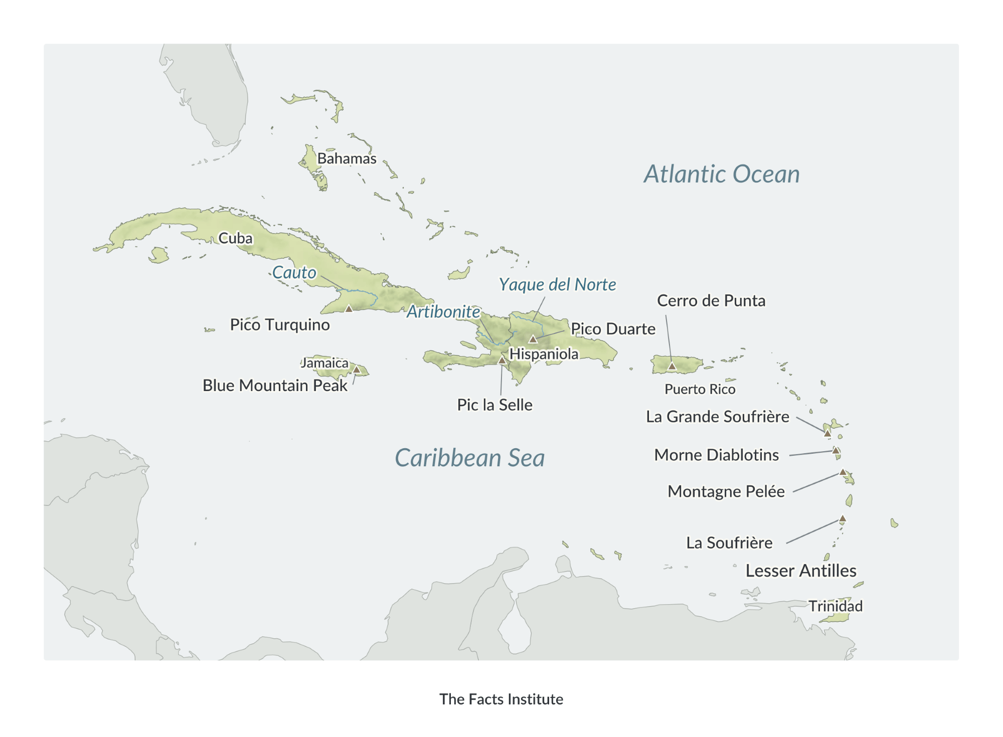
The Caribbean’s islands vary considerably in size and terrain. Cuba is the largest island in the region, while Hispaniola is shared by the Dominican Republic and Haiti.
Many of the larger islands have mountainous interiors. The Cordillera Central extends across the Dominican Republic and contains Pico Duarte, the highest mountain in the Caribbean, reaching approximately 3,100 metres (10,170 feet).
Other mountainous areas include the Blue Mountains in Jamaica, the Sierra Maestra in Cuba and the Massif de la Selle in Haiti.
Several islands in the Lesser Antilles are volcanic in origin, including Dominica, Martinique, Saint Lucia and Saint Vincent. Others, such as Barbados and many islands of The Bahamas, are predominantly low-lying and formed largely from limestone.
The Caribbean also has numerous rivers, particularly on its larger islands. The Yaque del Norte flows through the Dominican Republic and is one of the most important rivers on Hispaniola.
The physical map uses elevation colours and hillshading to distinguish mountainous terrain from lower-lying areas.
Caribbean political map
A political map of the Caribbean shows its independent countries, overseas territories, national capitals and territorial administrative centers.
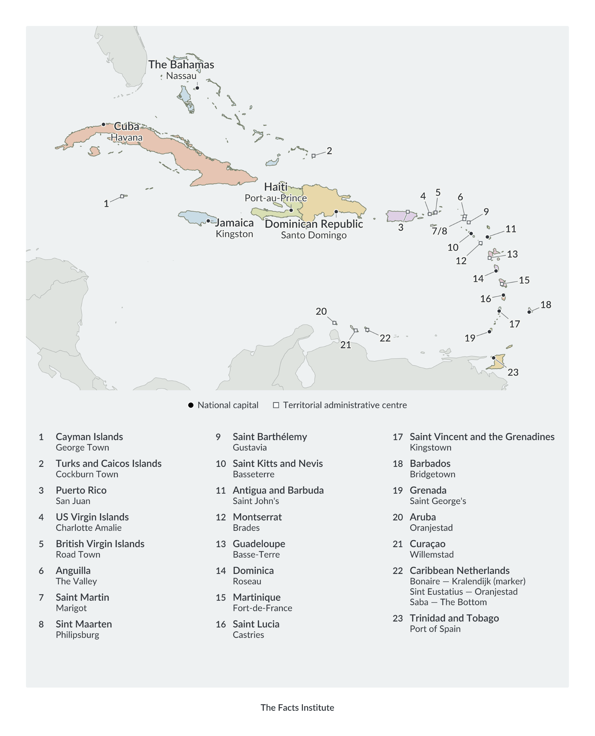
The Caribbean has 13 independent countries: Antigua and Barbuda, The Bahamas, Barbados, Cuba, Dominica, the Dominican Republic, Grenada, Haiti, Jamaica, Saint Kitts and Nevis, Saint Lucia, Saint Vincent and the Grenadines, and Trinidad and Tobago.
The region also includes territories associated with the United Kingdom, France, the Netherlands and the United States.
Puerto Rico and the United States Virgin Islands are US territories, while Guadeloupe and Martinique are French overseas regions. British territories include the Cayman Islands, Anguilla, Montserrat and the British Virgin Islands.
Aruba, Curaçao and Sint Maarten are constituent countries within the Kingdom of the Netherlands. Bonaire, Sint Eustatius and Saba are special municipalities of the Netherlands, collectively known as the Caribbean Netherlands.
The political map identifies the region’s countries and territories alongside their capitals and administrative centers. Numbered markers and a corresponding key help identify smaller islands where labels would otherwise be crowded.
Cuba is the largest Caribbean country by land area, while Saint Kitts and Nevis is the smallest independent country. Cuba, Haiti and the Dominican Republic are among the region’s most populous countries.
More Caribbean maps and geography resources
Explore more Caribbean resources, including:
These resources provide additional ways to study the Caribbean, compare its countries and territories, and practise identifying geographical locations.
Map sources: Terrain elevation data from USGS (SRTM and GMTED2010) and NOAA (ETOPO1), via Mapzen/AWS.

Caitriona Maria is an education writer and owner of The Facts Institute. With seven years of teaching experience and a background in educational content, she specialises in creating clear reference resources about countries, geography and global topics.