Central America is a region of North America connecting North and South America. It consists of seven countries: Belize, Costa Rica, El Salvador, Guatemala, Honduras, Nicaragua and Panama.
Explore the interactive map above to discover Central America’s countries, capital cities and geographical features. Select a country to view information about its population, area, capital and natural features, or use the map controls to explore different layers.
Where is Central America on the world map?
Central America is located between Mexico to the north and Colombia to the southeast. It forms a narrow land bridge connecting North America and South America, with the Pacific Ocean to the west and the Caribbean Sea to the east.

The region extends from Guatemala and Belize in the north to Panama in the southeast. Although geographically part of North America, Central America is commonly treated as a distinct region because of its location, physical geography and shared historical and cultural characteristics.
Much of Central America is mountainous, with volcanic ranges, tropical forests, coastal plains and numerous rivers. The region also contains important waterways, including the Panama Canal, which connects the Atlantic and Pacific oceans.
Central America’s position between two continents has made it an important corridor for wildlife, migration and trade.
Central America physical map
A physical map of Central America shows the region’s natural features, including mountain ranges, volcanoes, rivers, lakes, coastal plains and differences in elevation.
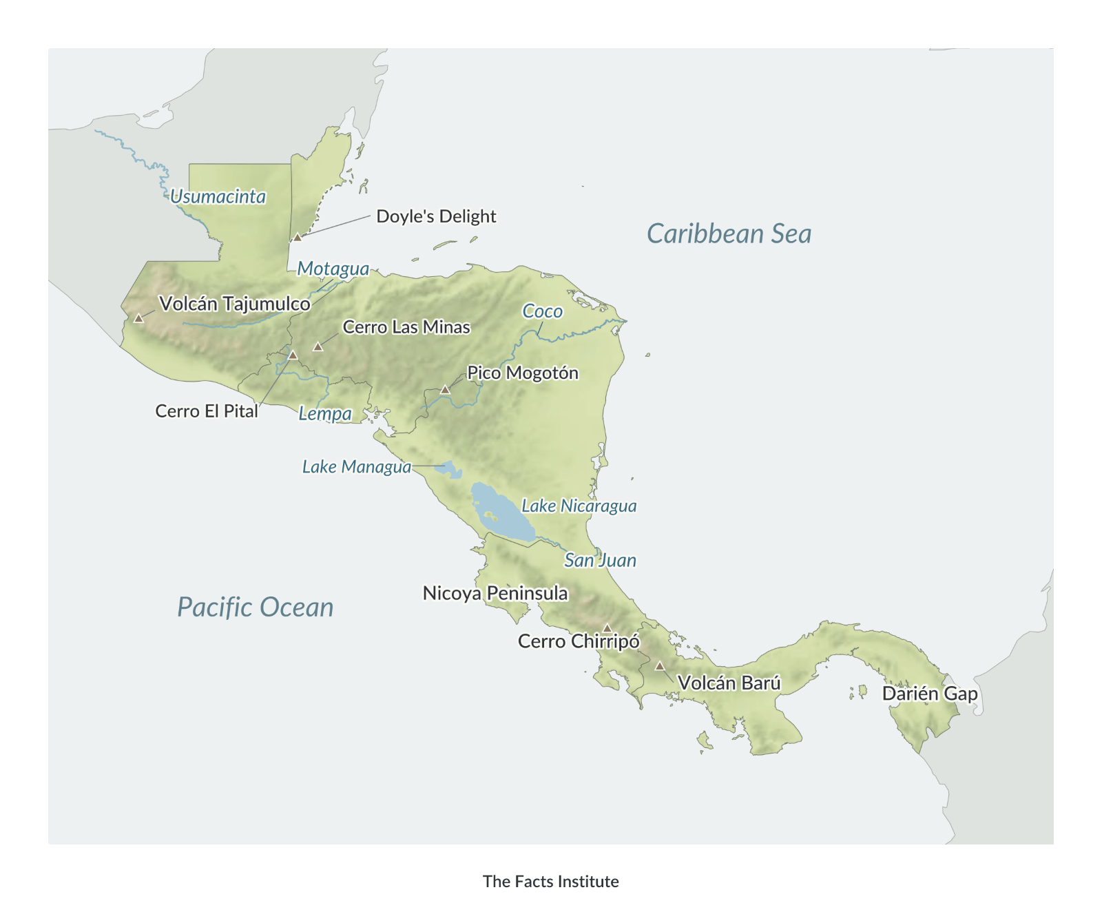
Central America’s landscape is characterized by mountainous terrain, particularly along its Pacific side. The map uses elevation colors and hillshading to distinguish highlands from lower-lying areas.
The highest mountain in Central America is Volcán Tajumulco in Guatemala, rising approximately 4,220 meters (13,845 feet) above sea level.
Other significant peaks shown on the map include Doyle’s Delight in Belize, Cerro Las Minas in Honduras, Cerro El Pital in El Salvador, Pico Mogotón in Nicaragua, Cerro Chirripó in Costa Rica and Volcán Barú in Panama.
Several major rivers are also identified. The Usumacinta flows along part of the Guatemala–Mexico border, the Motagua crosses Guatemala, and the Coco forms part of the border between Honduras and Nicaragua. The map also shows the Lempa River and the San Juan River, which connects Lake Nicaragua to the Caribbean Sea.
Lake Nicaragua is the largest lake in Central America. Nearby Lake Managua lies to its northwest. Both lakes are located in Nicaragua.
Other geographical features identified include Costa Rica’s Nicoya Peninsula and the Darién Gap in eastern Panama, near the border with Colombia.
Central America political map
A political map of Central America shows the region’s seven independent countries, their international borders and national capitals.
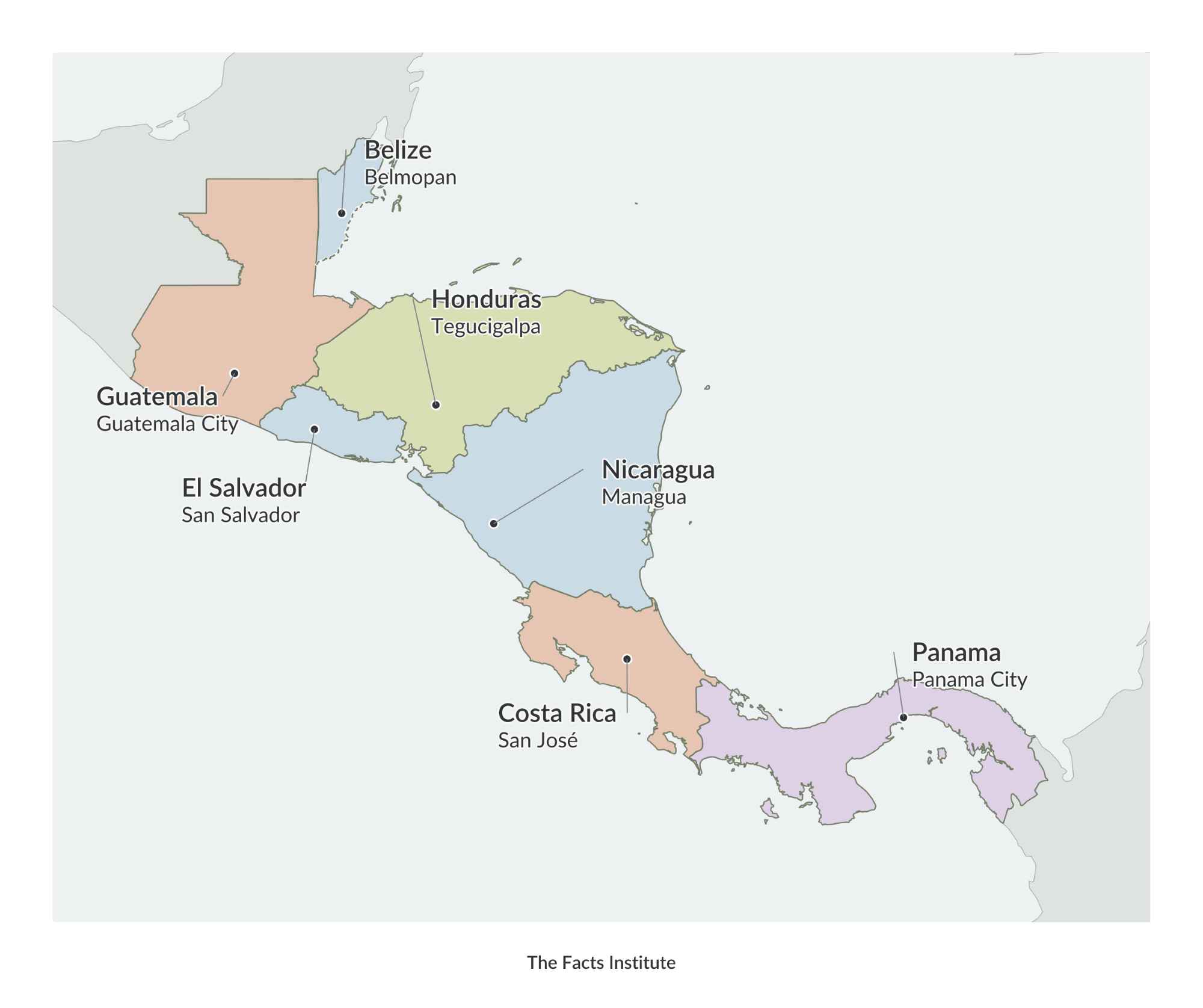
Guatemala is the most populous country in Central America, while Nicaragua is the largest by land area. El Salvador is the smallest country in the region by land area.
The countries differ considerably in population, terrain and settlement patterns. Guatemala has extensive highland areas and a large population, while Belize has a relatively small population and a Caribbean coastline.
Costa Rica and Panama occupy the southern part of Central America, with Panama forming the land connection to South America.
The region’s political boundaries reflect its history, including Spanish colonial rule and the development of independent states during the 19th century. Belize, formerly British Honduras, has a distinct British colonial history and became independent in 1981.
The political map identifies each country and its capital city, making it useful for studying Central America’s political geography and the locations of its major population and administrative centers.
More Central America maps and geography resources
Explore more maps and geography resources, including:
These resources provide additional ways to explore the geography of the Americas, compare countries and study their physical and political features.
Map sources: Terrain elevation data from USGS (SRTM and GMTED2010) and NOAA (ETOPO1), via Mapzen/AWS.

Caitriona Maria is an education writer and owner of The Facts Institute. With seven years of teaching experience and a background in educational content, she specialises in creating clear reference resources about countries, geography and global topics.