Melanesia covers a group of islands in the southwestern Pacific Ocean, although the exact boundaries of the region can vary depending on the definition used.
In broad terms, the region stretches from the island of New Guinea in the west through the Solomon Islands and Vanuatu to Fiji in the east.

There is no single, universally accepted scope for Melanesia, but most geographic classification systems share a similar core region.
List of countries in Melanesia
For clarity and consistency, this page follows the United Nations (UN) geoscheme, which defines Melanesia as consisting of four sovereign countries:
- Papua New Guinea
- Solomon Islands
- Fiji
- Vanuatu
The UN geoscheme also places New Caledonia within the Melanesian region. However, New Caledonia is a special collectivity of France, not an independent country.
Melanesian countries table
The table below lists the Melanesian countries along with their capitals, population estimates, and land area, based on international data sources.
| Country | Country Capital | Country Code | Population (Thousands) | Area (km²) |
|---|---|---|---|---|
| Fiji | Suva | FJ | 928.78 | 18,274 |
| Papua New Guinea | Port Moresby | PG | 10,576.50 | 462,840 |
| Solomon Islands, The | Honiara | SB | 819.20 | 28,896 |
| Vanuatu | Port-Vila | VU | 327.78 | 12,189 |
For broader context, you can also explore how these nations compare in size and population across the continent.
Countries in Oceania map
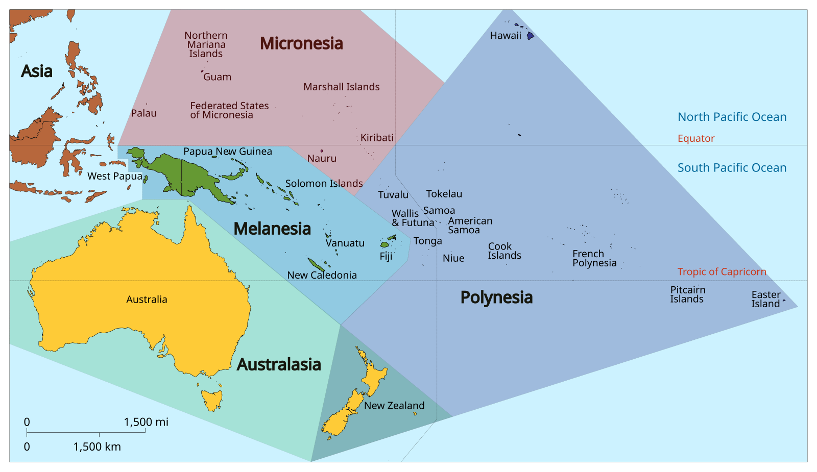
Melanesia lies northeast of Australia and east of Indonesia, forming one of the three Pacific island subregions of Oceania alongside Polynesia and Micronesia.
The region includes large mountainous islands, volcanic archipelagos, and extensive coral reef systems, with Papua New Guinea occupying the eastern half of the island of New Guinea and forming the western anchor of the Melanesian world.
How Melanesia is defined
UN Geoscheme (most common)
The United Nations geoscheme is the most widely used modern classification for Melanesia.
It is applied by the UN, World Bank, and international statistical agencies and includes the four sovereign countries listed above.
The geoscheme is geographic, rather than cultural or political, and is designed for consistency in global data reporting.
Historical and cultural background
The term Melanesia originates from Greek words meaning “black islands,” a label introduced by European explorers in the nineteenth century.
Historically, Melanesia has been home to highly diverse Indigenous societies, with thousands of languages spoken across the region. Despite geographic proximity, Melanesian cultures vary significantly from island to island.
Today, Melanesia is recognized primarily as a geographic subregion of Oceania, while cultural identity is understood to be complex, local, and not uniform across national borders.
Global regions map
To place Melanesia within the wider UN classification system, the global regions map below shows how all world subregions are organized.
The UN geoscheme groups every member state into a clearly defined region to allow consistent comparisons across countries and continents. Antarctica is excluded because the framework applies only to UN member states.
Within Oceania, the UN recognizes four subregions: Australia and New Zealand, Melanesia, Micronesia, and Polynesia.
In total, the geoscheme identifies 22 geographical subregions worldwide.

Caitriona Maria is an education writer and owner of The Facts Institute. With seven years of teaching experience and a background in educational content, she specialises in creating clear reference resources about countries, geography and global topics.