Europe is the second-smallest continent, located in the Northern Hemisphere between the Atlantic Ocean and Asia. It is home to a diverse range of countries, landscapes, and cultures, from the fjords of Norway to the Mediterranean coast and the vast plains of Eastern Europe.
Explore the interactive map above to discover Europe’s countries, capital cities, and geographical features. Select a country to view information about its population, area, capital, and natural features, or use the map controls to explore different layers.
Where is Europe on the world map?
Europe occupies the western portion of the Eurasian landmass. It is bordered by the Arctic Ocean to the north, the Atlantic Ocean to the west, and the Mediterranean Sea to the south.
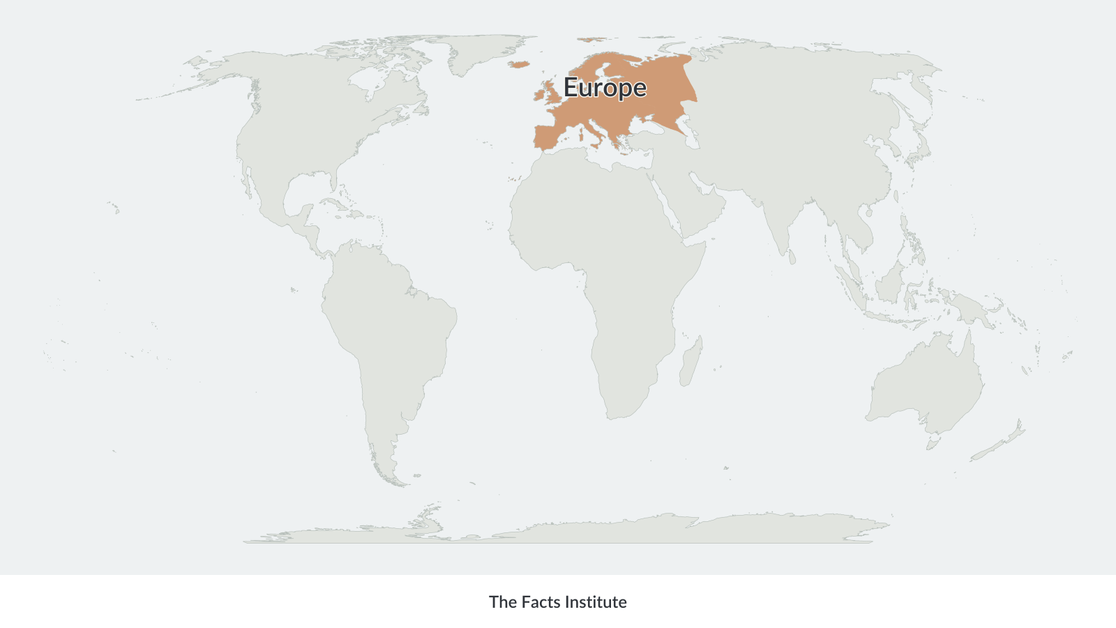
Europe’s eastern boundary with Asia is generally associated with the eastern edge of the Ural Mountains, then along the Emba River to the shore of the Caspian Sea, though the precise geographical division varies between classifications. The Black Sea and Caucasus region form part of the continent’s southeastern geographical setting.
Europe is commonly divided into four major geographical regions: Northern Europe, Eastern Europe, Southern Europe, and Western Europe. Central Europe is also widely used as a geographical and cultural designation.
The continent contains a wide variety of landscapes, including mountain ranges, extensive lowland plains, forests, rivers, lakes, and long stretches of coastline. Its numerous peninsulas and islands contribute to its distinctive geography.
Europe physical map
A physical map of Europe shows the continent’s natural features, including mountain ranges, rivers, lakes, plains, and differences in elevation.
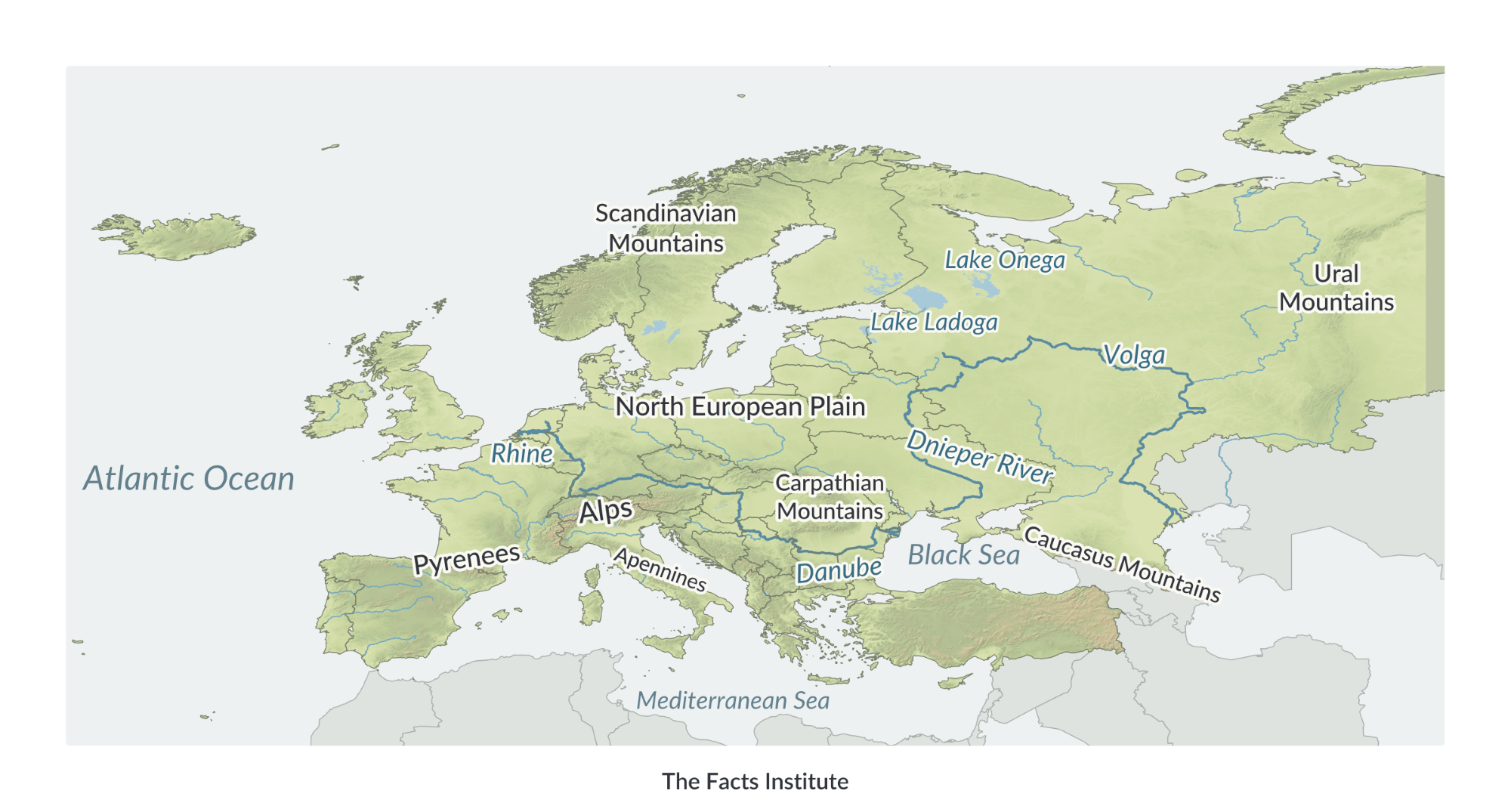
Europe’s terrain varies considerably. The Alps extend across parts of Central and Western Europe, while the Pyrenees form a natural barrier between Spain and France. Other important mountain ranges include the Carpathians, the Apennines, the Scandinavian Mountains, and the Caucasus.
Mount Elbrus in the Caucasus Mountains of southern Russia is generally recognized as Europe’s highest mountain, rising 5,642 meters (18,510 feet) above sea level. The highest peak in the Alps is Mont Blanc, at approximately 4,807 meters (15,773 ft).
Other notable mountains include the Matterhorn, Grossglockner, Triglav, Mount Olympus, Galdhøpiggen, and Ben Nevis. These and other geographical features can be explored in the interactive map above.
Europe also has an extensive network of rivers. The Volga is the continent’s longest river, flowing through Russia into the Caspian Sea. The Danube passes through or along several European countries before reaching the Black Sea, while the Rhine is an important waterway connecting Central Europe with the North Sea.
Other major rivers shown include the Dnieper, Don, Vistula, Rhône, Po, Elbe, Loire, Tagus, and Shannon.
Northern Europe is particularly rich in lakes. Lake Ladoga in northwestern Russia is the largest freshwater lake located entirely in Europe. Other important lakes include Onega, Vänern, Vättern, Saimaa, and Peipus.
Farther south, Lake Geneva lies along the Switzerland–France border, Lake Balaton is located in Hungary, and Lake Ohrid extends across the Albania–North Macedonia border.
Much of Northern and Eastern Europe consists of broad lowlands, including the North European Plain. In contrast, the mountainous landscapes of Southern Europe are shaped by high elevations, deep valleys, and tectonic activity.
Europe political map
A political map of Europe shows the continent’s countries, international borders, and national capitals.
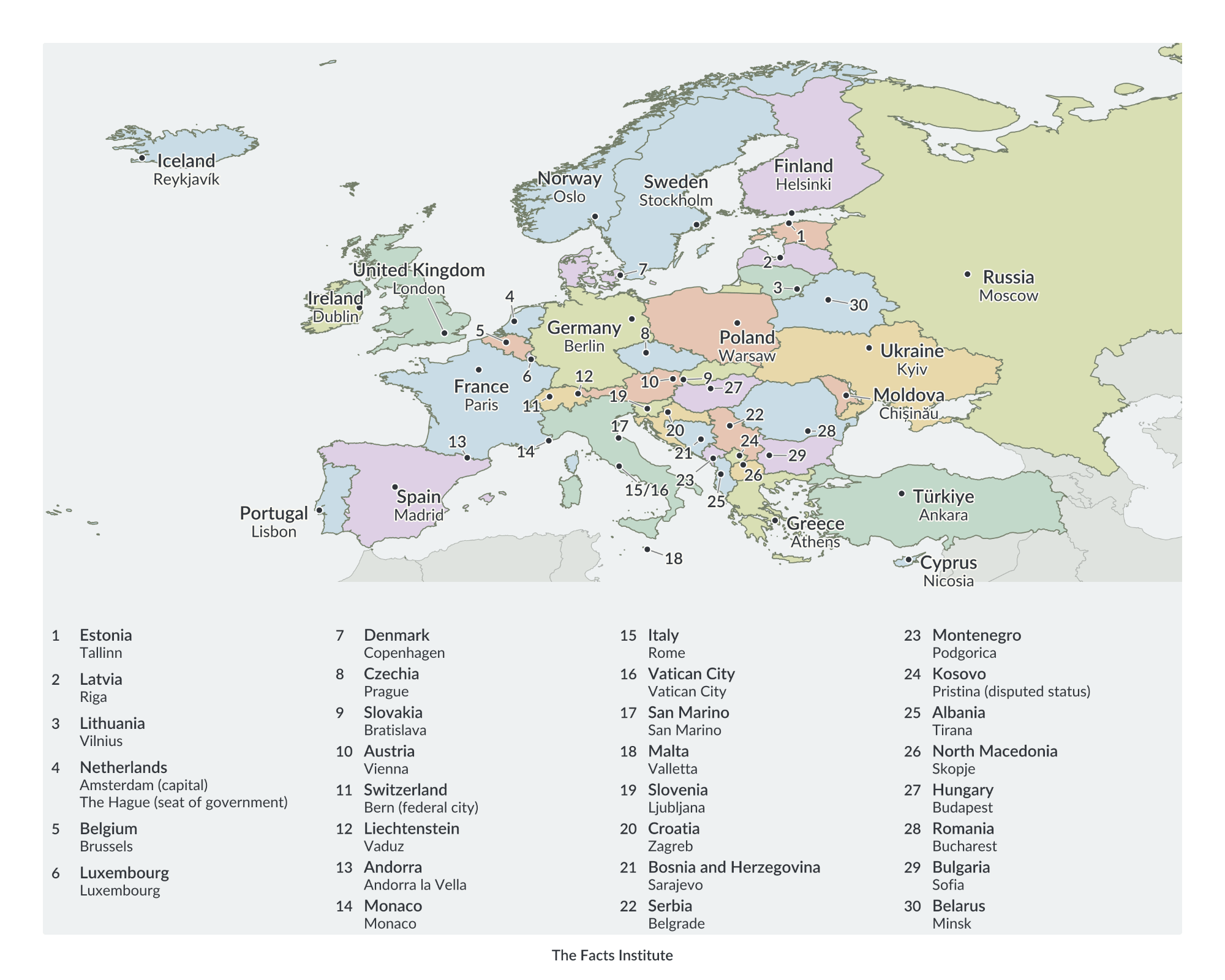
Europe is commonly described as having 49 countries, although the exact number varies depending on how transcontinental countries, disputed territories, and geographical boundaries are classified.
Russia is the largest country associated with Europe by total area, although most of its territory lies in Asia. France is the largest country located entirely within Europe. Germany is the most populous country located wholly in Europe.
The continent also contains several very small independent states, including Vatican City, Monaco, San Marino, Liechtenstein, Andorra, and Malta. Vatican City is the smallest independent state in the world.
Some countries extend across the traditional boundary between Europe and Asia. Russia and Türkiye are two prominent examples. Cyprus is geographically associated with Western Asia but is often included in European political and cultural classifications, particularly because it is a member of the European Union.
Kosovo is shown separately on the interactive map, although its independence is not universally recognized.
Europe’s political geography reflects centuries of changing borders, the development of nation-states, and the formation and dissolution of larger political unions. The continent’s present-day borders have been influenced by major historical events, including the two World Wars and the breakup of the Soviet Union and Yugoslavia.
The European Union consists of 27 member states, but it should not be confused with the continent of Europe. Several European countries, including Norway, Switzerland, and the United Kingdom, are not EU members.
The political map provides a useful reference for identifying European countries, their capitals, and their geographical relationships.
Explore more maps and geography resources, including:
These resources provide additional ways to explore Europe’s geography, compare countries, and learn their locations, capitals, and physical features.
Map sources: Terrain elevation data from USGS (SRTM and GMTED2010) and NOAA (ETOPO1), via Mapzen/AWS.

Caitriona Maria is an education writer and owner of The Facts Institute. With seven years of teaching experience and a background in educational content, she specialises in creating clear reference resources about countries, geography and global topics.